Dutch Corner Land Warrants
Thanks to Bill Bowser for all of his hard work on the map! It's wonderful!
Please be aware....the maps may be slow loading onto your computer due to their size!
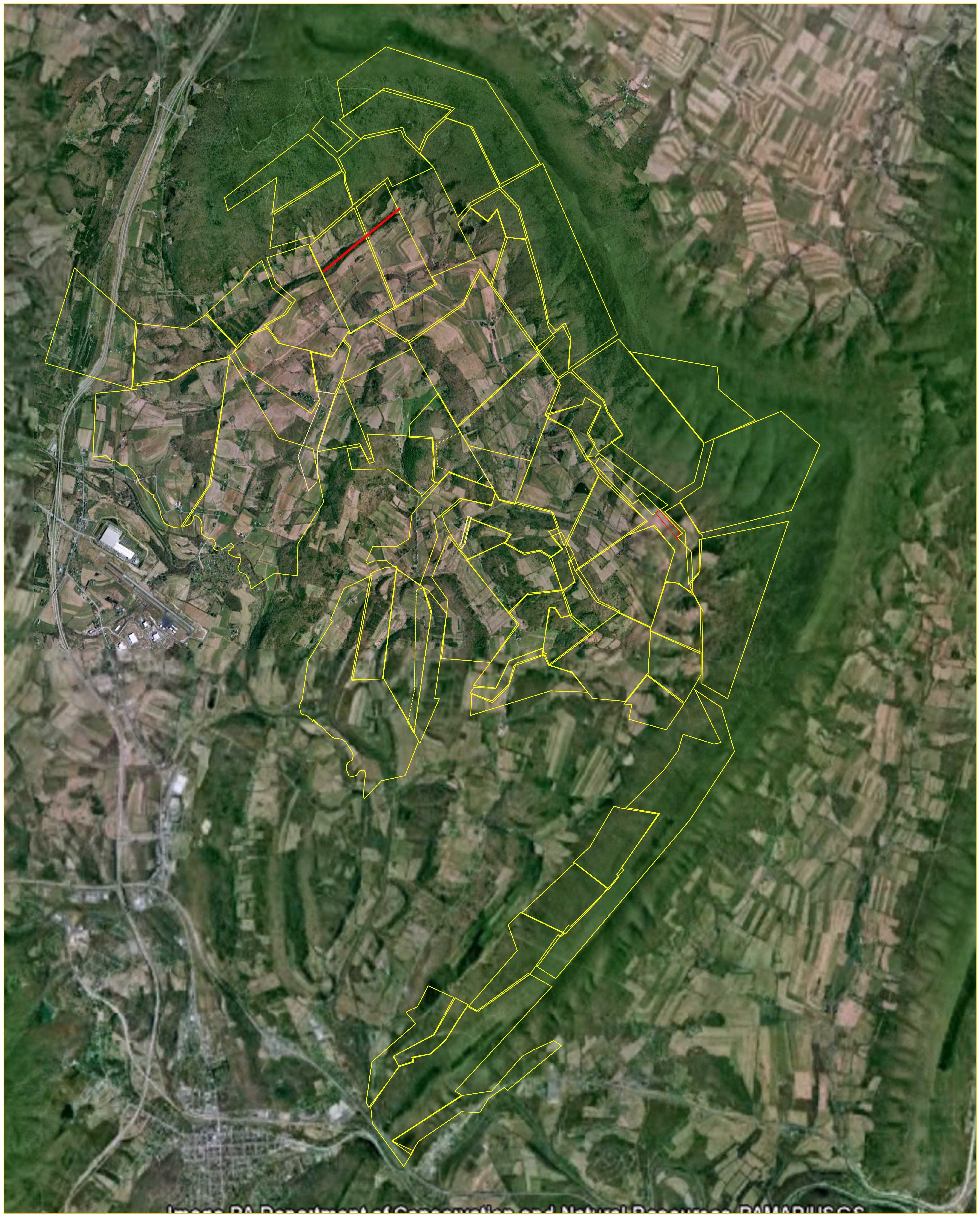
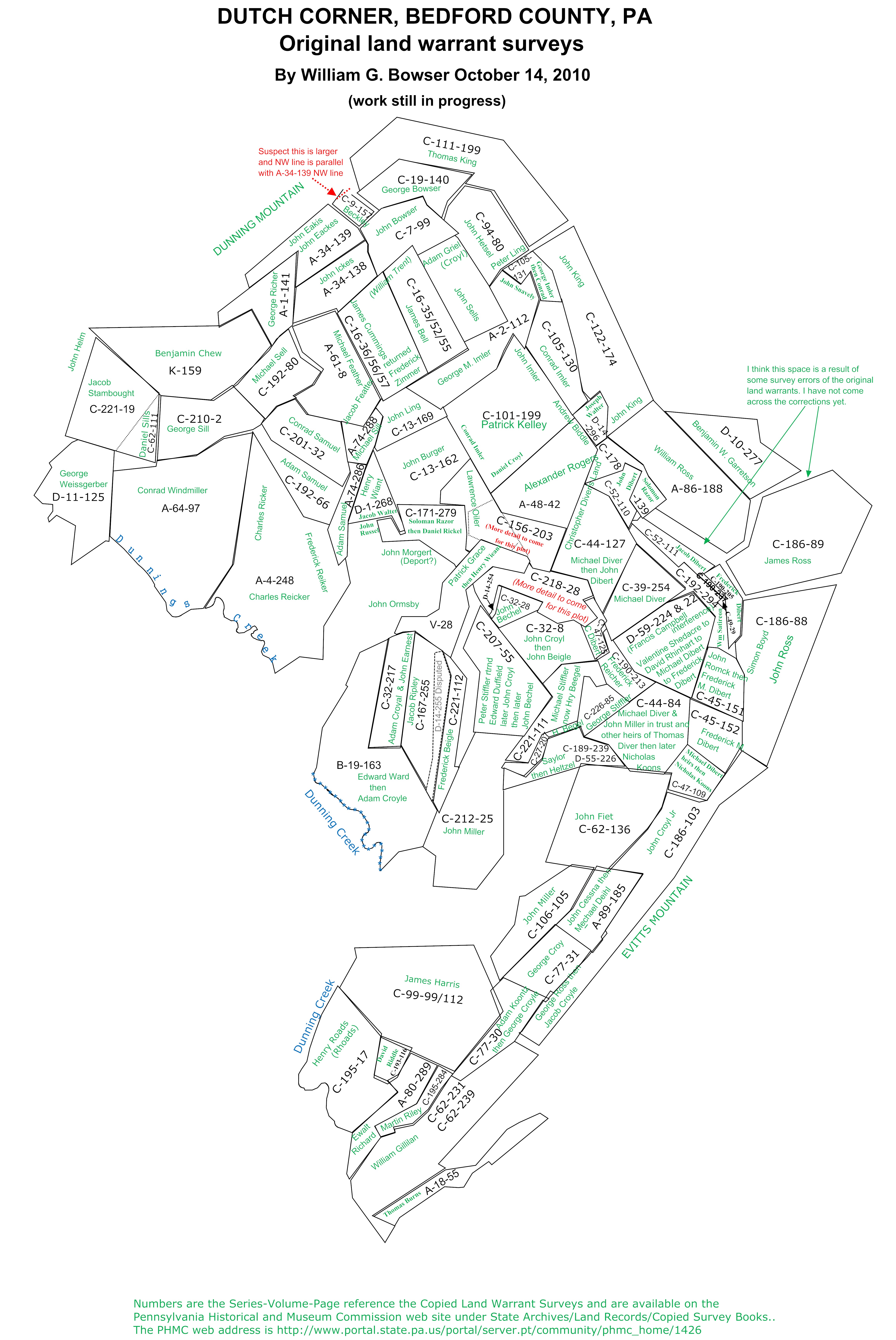
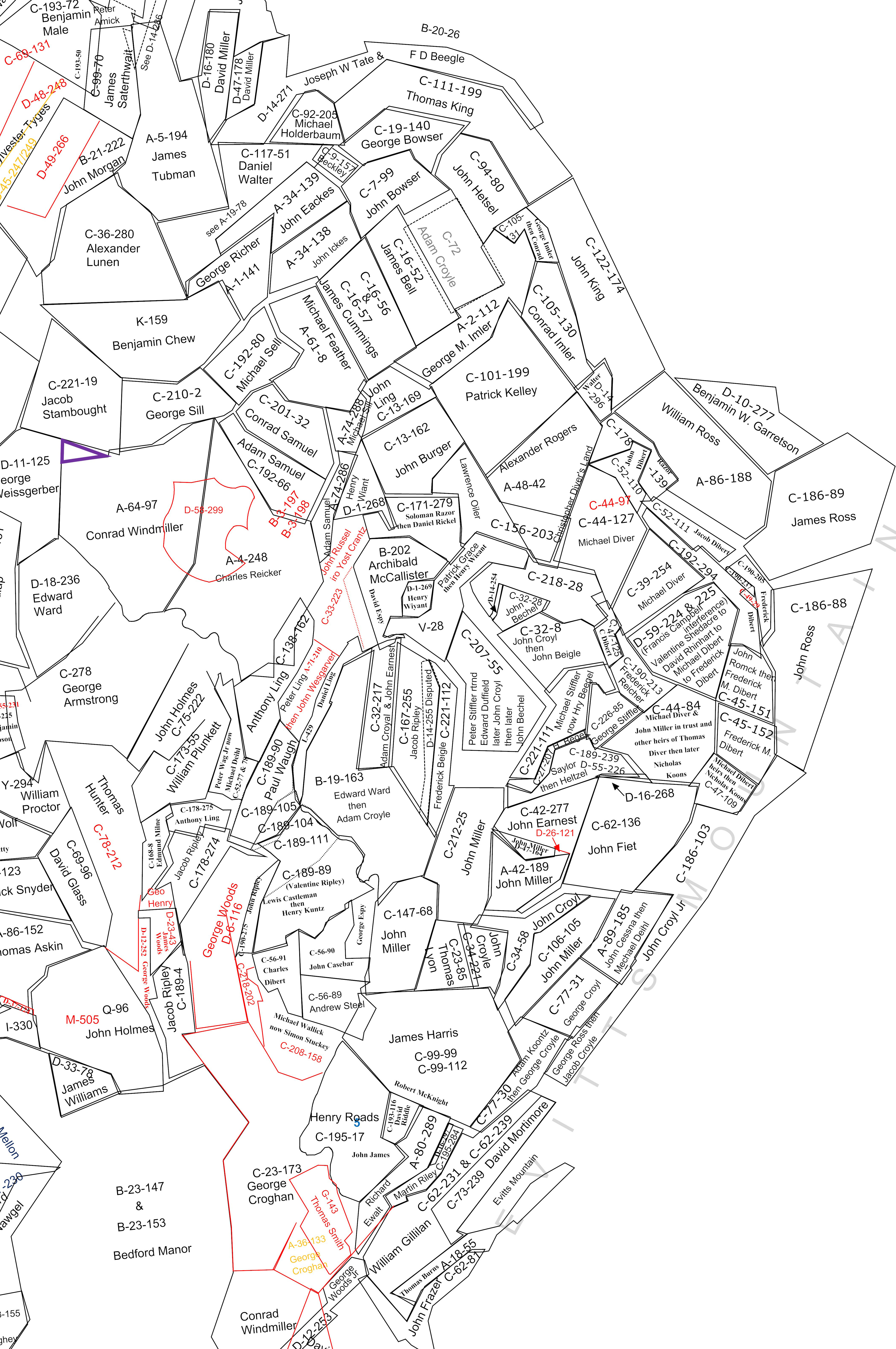
Here's the link to a Warrant Map over a Topographic Map. Keep in mind that this map is approximate, and is still being worked on!
Click here to view the Dutch Corner Land Warrant Map from October 2010.
Click here to view the Dutch Corner Land Warrant Map from Novemberr 2010
Click here to view the newest version of the February 4, 2011 Version of the Dutch Corner Land Warrant Map. Here are the names of the people who were assigned Land Warrants and the link to the PA Archives site where that warrant can be viewed: Bechel, John (aka Beegle, John) for 43 acres, Warrant Date: 5-13-1839, Surveyed: 11-10-1839 - c-32-28 Beegle, Frederick (spelled Beigle) from Stiffler, Peter to Beegle, Henry (4-23-1870) for 83 acres 150 perches, Warrant Date: 12-21-1785, Surveyed: 1789 & 11-10-1839 - c-221-112 Beegle, Henry (spelled Beegel) for 24 acres 66 perches, Warrant Date: 7-27-1844, Surveyed: 9-4-1844 - c-27-207 Beekley, Henry for 27.5 acres, Warrant Date: 7-24-1793, Surveyed: 7-1-1802 - c-9-157 Bell, James for 185 acres 21 perches, Warrant Date: 5-31-1762, Surveyed: 2-21-1811 - c-16-52 Bowser, George to Heltzel, Charles (1-11-1872) for 136 acres 50 perches, Warrant Date: 3-22-1802, Surveyed: 5-6-1802 - c-19-140 Bowser, John (aka Bouser) for 153 acres, Warrant Date: 1-13-1774, Surveyed: 9-24-1774 - c-7-99 Burger, John for 193 acres 45 perches, Warrant Date: 3-3-1823, Surveyed: 1823 & 5-12-1827 - c-13-162 Burns, Thomas for 111 acres 69 perches, Warrant Date: 9-2-1785, Surveyed: 5-26-1789 - a-18-55 Campbell, Francis (part of which interferes with conveyence to Shedacre, Valentine conveyed to Rhinehart, David then to Dibert, Michael then to Dibert, Frederick) for 243 acres 29 perches, Warrant Date: 6-8-1762, Surveyed: 6-14-1765 - d-59-224 Cessna, John for 138 acres 53 perches, Warrant Date: 4-30-1853, Surveyed: 5-2-1853 - a-89-185 Croyle, George for 124 acres, Warrant Date: 6-20-1853, Surveyed: 6-23-1853 - c-77-31 Croyle, John for 157 acres 8 perches, Warrant Date: 10-29-1818, Surveyed: 4-2-1821 ? - c-32-8 Cummings, James for 241 acres 53 perches, Warrant Date: 5-31-1762, Surveyed: 5-10-1765 - c-16-56 Cummings, James for 227 acres 109 perches, Warrant Date: 5-31-1762, Surveyed: 5-10-1765 - c-16-57 Dibert, Christopher to Dibert, Andrew (executor for Christopher, in trust for widow & heirs) for 31.75 acres, Warrant Date: 2-18-1818, Surveyed: 11-6-1818 - c-47-125 Dibert, Frederick for 102.75 acres, Warrant Date: 3-14-1826, Surveyed: 12-20-1833 - c-45-152 Dibert, Jacob for 55 acres, Warrant Date: 11-16-1818, Surveyed: 1-28-1819 - c-52-111 Dibert, John for 40 acres, Warrant Date: 11-12-1792, Surveyed: 11-1827 - c-52-110 Dibert, Michael for 2 acres 129 perches, Warrant Date: 6-22-1885, Surveyed: 6-26-1885 - c-49-29 Dibert, Michael (aka Diver, Michael) for 145.5 acres, Warrant Date: 12-12-1766, Surveyed: 3-9-1768 - c-39-254 Dibert, Michael (aka Diver, Michael), Miller, John and heirs of Dibert, Thomas in trust for 212 acres, Warrant Date: 12-12-1766, Surveyed: 4-22-1788 - c-44-84 Dibert, Michael (in trust for: Dibert, Michael, John & Frederick and their sister Margaret wife of John Miller) to Dibert, John 9-30-1788 for 220 acres, Warrant Date: 12-12-1766, Surveyed: 3-9-1768 - c-44-127 Dibert, Michael to Koontz, Charles & Adriel for 76 acres 143 perches, Warrant Date: 11-12-1792, Surveyed: 6-16-1869 - c-47-109 Duffield, Edward to Stiffler, Peter (9-30-1780) for 250 acres 56 perches, Warrant Date: 9-27-1766, Surveyed: 3-10-1767 - c-207-55 Ewalt, Richard ((see C-193-115)) for 110.75 acres, Warrant Date: 2-10-1794, Surveyed: 9-4-1795 - a-80-289 Feit, John (also listed as Fiet) for 338.25 acres, Warrant Date: 5-31-1762, Surveyed: 5-9-1765 - c-62-136 Fetter, Michael (listed as "Feather") for 229 acres, Warrant Date: 3-21-1765, Surveyed: 9-1774 - a-61-8 Garretson, Benjamin for 201 acres 10 perches, Warrant Date: 10-15-1867, Surveyed: 1-26-1886, resurveyed 5-23-1886 - d-10-277 Gillian, William ((See C-62-231)) for 404 acres 50 perches, Warrant Date: 4-10-1794, Surveyed: 9-4-1795, resurveyed 3-27-1832 - c-62-239 Gillian, William to Mortimer, David (6-7-1870 for 132 acres 85 perches) and Lingenfelter, J.W. (12-4-1871 for 271 acres 125 perches) for 404 acres 50 perches, Warrant Date: 4-10-1794, Surveyed: 9-4-1795, resurveyed 3-27-1832 - c-62-231 Grace, Patrick to Heltzel, John (6-16-1825) for 179 acres, Warrant Date: 9-27-1766, Surveyed: 3-10-1767, resurveyed 8-22-1777 - v-28 Harris, James ((see C-99-112)) for 534.75 acres, Warrant Date: 5-27-1763, Surveyed: - c-99-99 Heltzel, John for 173.5 acres, Warrant Date: 1-12-1832, Surveyed: 3-28-1783 - c-94-80 Ickes, John for 142 acres, Warrant Date: 6-17-1808, Surveyed: 6-1-1809 - a-34-138 Ickes, John (listed as "Eackus") for 155 acres 70 perches, Warrant Date: 7-22-1809, Surveyed: 11-3-1809 - a-34-139 Imler, Conrad for 149 acres 149 perches, Warrant Date: 8-26-1845, Surveyed: 9-8-1845 - c-105-130 Imler, George Michael for 222 acres 125 perches, Warrant Date: 2-10-1786, Surveyed: 8-9-1789 - a-2-112 Imler, George to Imler, Conrad for 49 acres 73 perches, Warrant Date: 3-29-1794, Surveyed: 9-8-1845 - c-105-131 James, John from Ewalt, Richard and Riddle, David for 152 acres 85 perches, Warrant Date: 2-10-1794 & 5-23-1817, Surveyed: 9-4-1795, returned 1-4-1854 - c-193-115 Kelly, Patrick for 398.75 acres, Warrant Date: 5-31-1762, Surveyed: 5-11-1765 - c-101-199 King, John for 377 acres 135 perches, Warrant Date: 4-10-1794, Surveyed: 9-2-1795 - c-122-174 King, Thomas to Daniel Barlay (4-23-1870) for 384 acres 110 perches, Warrant Date: 4-10-1794, Surveyed: 9-8-1795 - c-111-199 Koontz, Adam for 123 acres 127 perches, Warrant Date: 6-13-1853, Surveyed: 6-16-1853 - c-77-30 Ling, John for 91 acres 80 perches, Warrant Date: 7-24-1793, Surveyed: 9-1825 - c-13-169 Miller, John for 237 acres, Warrant Date: 12-12-1766, Surveyed: 2-1768 - c-212-25 Miller, John to Kuntz, Adam (aka Koontz, Adam) and Kuntz, John (aka Koontz, John) (3-29-1828) for 163 acres, Warrant Date: 12-12-1766, Surveyed: 3-1768 - c-106-105 Oyler, Lawrence originally Rogers, Alexander for 75 acres 17 perches, Warrant Date: 5-31-1762 & 7-24-1793, Surveyed: 11-9-1822 - c-156-203 Razor, Solomon to Rickle, Daniel for 140 acres, Warrant Date: 3-29-1820, Surveyed: 9-3-1846 - c-171-279 Reed, John R. to Dibert, Adam (4-26-1870) for 5 acres 51 perches, Warrant Date: 5-11-1842, Surveyed: 3-29-1847 - c-190-237 Reid, John P. to Fetter, Jacob D. (3-23-1870) for 45 acres 38 perches, Warrant Date: 7-18-1839, Surveyed: 5-9-1840 - c-190-205 Reiley, Martin to Lingenfelter, J.W. (2-4-1871) for 44 acres 60 perches, Warrant Date: 2-27-1793, Surveyed: 9-4-1795 - c-195-284 Resor, Solomon for 88 acres, Warrant Date: 1-1-1827, Surveyed: 2-15-1827 - c-178-139 Rhoads, Gabriel to Shoemaker, Abraham (4-6-1870) for 74 acres, Warrant Date: 4-3-1786, Surveyed: 4-2-1787 - c-190-213 Rhoads, Henry (aka Roads, Henry) for 285 acres, Warrant Date: 7-7-1762, Surveyed: 6-6-1765 - c-195-17 Richer, George for 121 acres, Warrant Date: 3-8-1790, Surveyed: 5-5-1795 - a-1-141 Ricker, Charles for 620 acres 109 perches, Warrant Date: 5-27-1763, Surveyed: 6-12-1765 - a-4-248 Riddle, David for 41 acres 128 perches, Warrant Date: 5-23-1817, Surveyed: 10-30-1817 - c-193-116 Ripley, Jacob for 196 acres 107 perches, Warrant Date: 7-10-1818, Surveyed: 7-17-1818 - c-167-255 Rogers, Alexander for 322.75 acres, Warrant Date: 5-31-1762, Surveyed: 5-11-1765 - a-48-42 Romick, George to Dibert, F.M. (5-19-1836) for 100 acres, Warrant Date: 3-28-1768, Surveyed: 9-5-1794 - c-45-151 Ross, George to Koontz, Adriel & Croyle, Jacob & John (6-2-1869) for 400 acres, Warrant Date: 4-10-1794, Surveyed: 9-5-1795 - c-186-103 Ross, John to Dibert, Michael & Adam (5-26-1869) for 418.75 acres, Warrant Date: 4-10-1794, Surveyed: 9-9-1795 - c-186-89 Ross, John to Dibert, Michael (5-26-1869) for 388 acres 140 perches, Warrant Date: 4-10-1794, Surveyed: 9-6-1795 - c-186-88 Ross, William patented to Daniel Barley for 366.5 acres, Warrant Date: 11-6-1831, Surveyed: 4-10-1795 - a-86-188 Samuels, Adam for 148 acres 117 perches, Warrant Date: 11-2-1774, Surveyed: 12-27-1785 - c-192-66 Samuels, Adam for 54.25 acres, Warrant Date: 2-9-1796, Surveyed: 3-29-1794 - a-74-286 Samuels, Conrad (aka Sammels, Conrad) for 162 acres 61 perches, Warrant Date: 5-27-1763 & 2-4-1774, Surveyed: 12-27-1785 - c-201-32 Satorias, William for 110 acres, Warrant Date: 12-16-1793, Surveyed: 12-6-1803 - c-192-294 Saylor, Jacob for 112 acres 35 perches, Warrant Date: 9-13-1785, Surveyed: 7-26-1786 - c-189-239 Sill, Michael for 49.5 acres, Warrant Date: 3-31-1786, Surveyed: 2-9-1796 - a-74-288 Sills, David from Fenace, Henry for 50 acres 73 perches, Warrant Date: 5-31-1762, Surveyed: 10-14-1822 - c-62-111 Sills, George for 195 acres 132 perches, Warrant Date: 12-16-1784, Surveyed: 12-16-1786 - c-210-2 Sills, Michael (aka Sells, Michael) for 144 acres 5 perches, Warrant Date: 2-8-1767, Surveyed: 3-20-1786 - c-192-80 Steell, Alexander (aka Stell�Kpart of which interferes with conveyence to Saylor, Jacob, who conveyed to Shurich, Adam, then was sold by sheriff to Heltzel, John) for 112 acres 35 perches, Warrant Date: 5-2-1767, Surveyed: - d-55-226 Stiffler, George to Koontz, Adriel (6-25-1869) for 61 acres 88 perches, Warrant Date: 7-18-1794, Surveyed: 6-15-1869 - c-226-85 Stiffler, Henry for 5 acres, Warrant Date: 3-20-1855, Surveyed: 3-26-1855 - d-14-254 Stiffler, Henry and Wiant, Henry for 178 acres 105 perches, Warrant Date: 12-21-1785, 6-12-1794, 7-8-1794, Surveyed: 4-2-1787, 4-22-1846 - c-218-28 Stiffler, Michael to Beegle, Henry (4-23-1870) for 60 acres, Warrant Date: 5-27-1816, Surveyed: 12-11-1817 - c-221-111 Stiffler, Peter for 61 acres 80 perches, Warrant Date: 12-21-1785, Surveyed: 8-25-1788 - c-221-113 Walter, Joseph for 90 acres, Warrant Date: 12-10-1813, Surveyed: 8-25-1815 - d-14-296 Ward, Edward for 489 acres, Warrant Date: 5-27-1763, Surveyed: 6-4-1765 - b-19-163 Weissgerber, George (aka Wisegarver, George) to Wisegarver, Daniel (6-30-1836) for 224 acres 110 perches, Warrant Date: 10-20-1766, Surveyed: 1-9-1791 - d-11-125 Wiant, Henry for 74.25 acres, Warrant Date: 6-12-1794, Surveyed: 3-15-1797 - d-1-268 Windmiller, Conrad for 630 acres 92 perches, Warrant Date: 5-27-1763, Surveyed: 6-12-1765 - a-64-97 Wright, John to Chew, Benjamin Esq. (10-29-1799) for 364.5 acres, Warrant Date: 10-28-1766 & 2-2-1768, Surveyed: 3-24-1768 - k-159